
In the bustling heart of Kigali, Rwanda, a young mother cradles her newborn, relieved to find a clinic nearby.
Across Northern Nigeria, health workers navigate previously overlooked settlements, bringing vaccines to children who might have gone unnoticed.
Meanwhile, in Nairobi, city engineers analyse flood-prone streets, determined to prevent the next disaster before it happens.
The recent Nairobi floods underscored the urgent need for action, and our rapid assessment with WRI Africa capitalized on Google’s Open Buildings dataset.
These seemingly unrelated moments share a quiet force behind them—Google’s Open Buildings dataset.
What started as an ambitious AI-driven mapping project is now an essential tool in Africa’s fight for better healthcare and climate resilience.
“This detailed data was instrumental in shaping our approach to fostering innovative nature-based solutions that will enhance Nairobi’s resilience and restore its vital river ecosystems”, says Walter Samuel, Project Manager, Geo Analytics, World Resources Institute (WRI).
“Open Buildings gives us the roof-level detail to build accurate population grids where traditional data are missing. Overlaying those grids with vaccine-coverage maps lets our joint WorldPop–AFENET teams pinpoint zero-dose pockets and guide vaccinators street by street, so no child is missed.” – said Dr. C. Edson Utazi, Associate Professor of Spatial Data Science, WorldPop, University of Southampton.
Bridging Healthcare Gaps in Rwanda and Nigeria
Healthcare planners in Rwanda, in collaboration with Sand Technologies, faced a challenge: many rural clinics were too far for patients to access safely.
With Open Buildings, they reshaped their blueprint, ensuring that 92% of the population now lives within 30 minutes of a medical center. For mothers, this could mean the difference between a safe delivery or a dangerous trip over long distances.
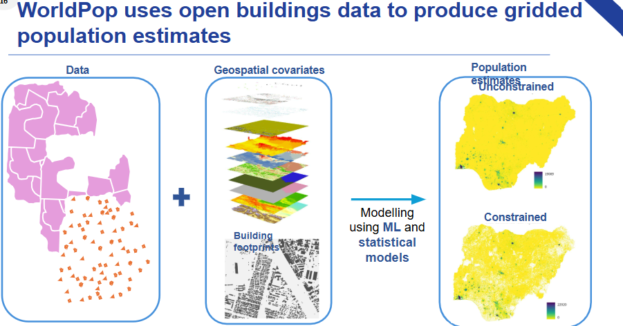
In Northern Nigeria, AFENET epidemiologists and WorldPop geographers stumbled upon 10,250 previously unmapped buildings—hidden pockets where thousands of children remained zero-dose, receiving no routine vaccines.


In just six months, using Open Buildings, vaccinators reached 70% of these children, rewriting their health future.
Predicting Floods Before They Happen
The scars of flooding run deep across Africa. From Nairobi’s 2024 devastation, where 278,000 people were displaced, to Johannesburg’s fast-growing settlements along the vulnerable Jukskei River, cities are struggling to protect their populations. This is where the World Resources Institute (WRI) saw an opportunity.
Using Open Buildings, WRI mapped flood risk in Dire Dawa, Kigali, Musanze, Gqeberha, and Johannesburg, layering AI-powered building footprints with hydraulic simulations.
The result? Block-by-block exposure maps that empower engineers to redirect resources efficiently and fortify vulnerable areas.
AI’s Role in Africa’s Future
With urban populations projected to double by 2035, Africa’s infrastructure challenges are growing. But AI-driven initiatives like Open Buildings prove that locally guided technology can bring real solutions—without locking problem-solvers behind paywalls.
Dr. Aisha Walcott-Bryant, head of Google Research Africa, sums it up best:
“These projects show what happens when local expertise meets open, scalable technology: mothers reach clinics sooner, children receive overdue vaccines, and city planners get ahead of the next flood. AI’s highest calling is to solve real-world challenges.”
From lifesaving clinics to climate-smart cities, Open Buildings is not just a dataset—it’s a catalyst for progress. And in Africa, where resilience meets innovation, the impact is only just beginning.
Call to action:
The Open Buildings dataset—along with sample code, tutorials and its new 2.5D layer—is freely available at g.co/openbuildings.